This post is the first of what I expect to be a three-part series describing my recent backpacking trip to the White Mountains. After my first draft reached almost 5,000 words, I figured it might be good to break it up into parts. Here’s Part 2. I’ll include a link to Part 3 as soon as it’s live. I hope you enjoy.
It was time. My new inReach had arrived. It was working. My gear was packed—again. I had warm clothes. I had backup diabetes supplies. My teaching commitments were over for the semester. After weeks of delay, I was finally ready to hike the Pemi Loop.
The plan was simple. I would leave early Saturday morning to drive 3.5 hours to the Lincoln Woods Trailhead (the same spot where Maria and I started our brief honeymoon adventure), then spend the rest of the day hiking 11 miles to the Guyot Shelter. The second day would be a short jaunt 6 miles from there to the Garfield Shelter. If I was feeling ambitious after so short a hike, I might also hike the last 13 miles of the loop that day. If not, I’d have plenty of time on a third day to take it easy covering those last miles and still getting home in the early evening on Monday. I knew the miles through some snow and rugged mountains might be hard, but I’d been hiking 14 miles in a day with my pack through relatively hilly terrain without difficulty, so I figured this trip would be well within my capacity. But I’d been naïve, and the White Mountains would soon show me the error in my expectations.
The first morning started with a torrential downpour that lasted for most of the drive north, but as forecasted, it had faded to barely a light drizzle by the time I arrived at the trailhead. I put on my raincoat and pants, ate lunch, bolused for a small portion of it, dropped my basal to 50%, finished my extra water, and made my way out into the cold, damp wilderness. It was just about 13:00.

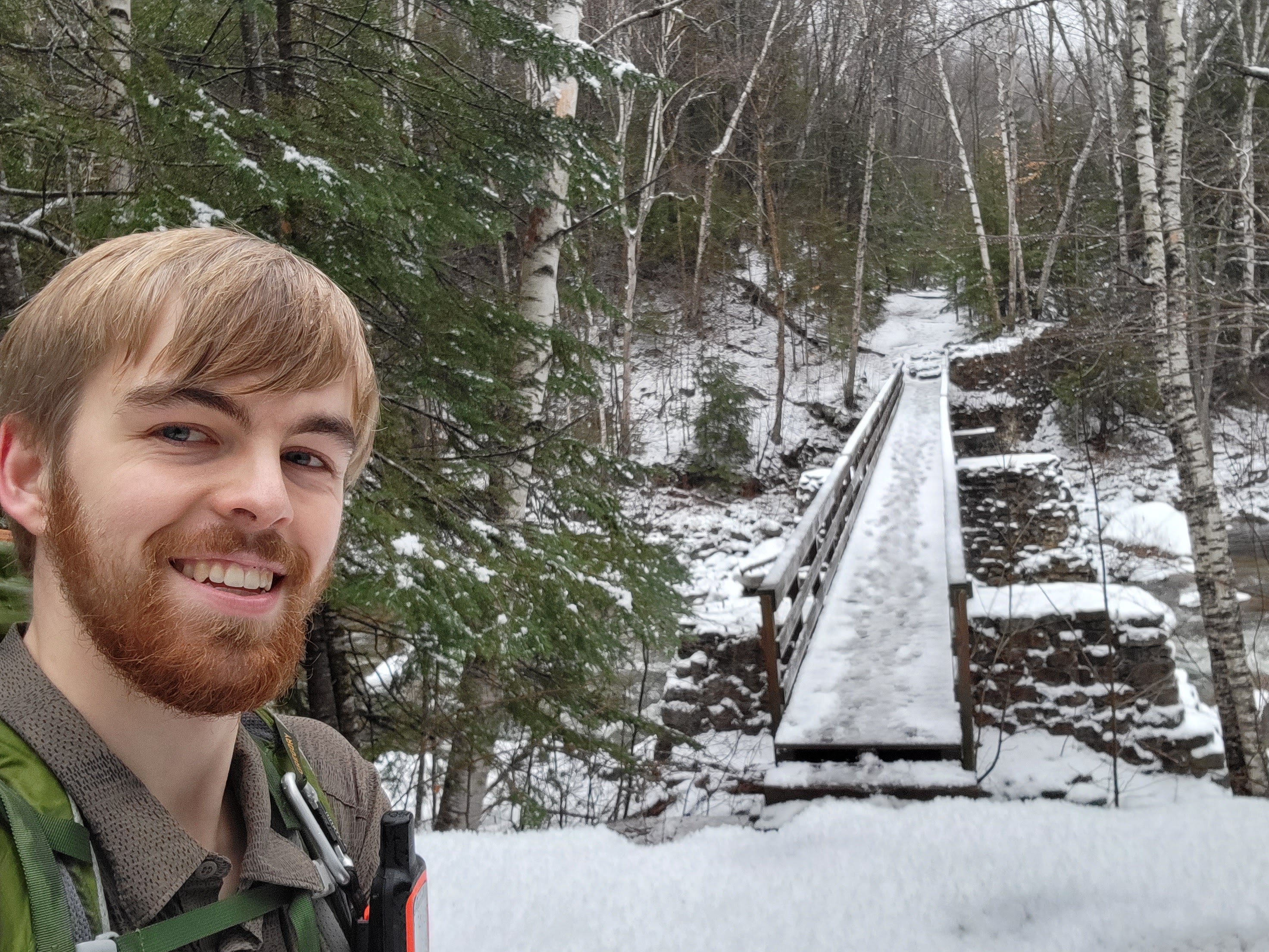
The first few miles of the loop follow an old rail bed along the Pemigewasset River that was once used for logging in the area. The inch or two of snow from before the morning rain was now a thick layer of slush over the entire trail, soaking my feet in freezing mush and reducing traction. Fortunately, the trail wasn’t slick enough to slow me too much, and after a few minutes of uncomfortable cold, the temperature inside my plastic bag-lined trail runners equilibrated to a tolerable level. A sign at the beginning of the trail warning of a closed bridge ahead had me worried, but when I arrived at it, it looked stable enough that I just crossed it anyway (following two other nearby hikers) rather than trying to find an alternative dry crossing. Somewhere between the sign and the bridge, I came across two-thirds of a snow person that had either lost its head somewhere, or never had one in the first place.


I made my first choice of pain after about 3 miles when I decided to take the side trail to see Franconia Falls. Maria and I hadn’t been able to find our way across from the other side of the river during our honeymoon, so I figured this would be a good opportunity to discovered what we’d missed out on. Heading off of the flat rail bed to climb up to the falls, the poor traction from the slush forced me to move more slowly and deliberately. The signs said the falls were 0.4 miles off the trail, but I only turned back after about 0.6 miles and another sign saying the trail ended. I had been imagining spectacularly tall, frozen cascades, so when I only saw moderately steep rocks with a bit of water flowing over them, I had continued on past looking for something more impressive.

After the slow climb up to the falls, it was finally time to put on my microspikes for traction. I was a little disappointed to have added 45 minutes and a little over a mile to my hike, but was still glad to have seen the falls. The detour’s contribution to my pain wouldn’t become apparent until later that evening.
Back on the main trail, I crossed over a long bridge I’d spotted during the honeymoon trip and continued paralleling the Pemi River on the rail path. This was about the time I started feeling some aching in my legs and an inkling of foreboding. If I was getting tired barely halfway through the day, I was going to have a rough evening ahead of me. The slushy terrain was clearly taking more out of me than I had expected, and I began to wonder if I would regret the extra 1.2 miles I’d added to see Franconia falls.
After another 1.8 miles, the trail turned north and began the long climb up to Mt. Bond. A few things happened near here to make the going more difficult. First, I realized I had left my phone’s charging cable back at the car, so despite carrying a battery pack, I had no way to get power from it to my phone. I’d been planning to use my phone as my primary means of navigation, so this was somewhat concerning. I didn’t want to hike three hours back to the car and put myself a day behind, so it was fortunate I had a good paper map and a compass. I figured I could get by on those and trail markings if my phone died on me.
The second difficulty was the setting sun. Starting the hike at 13:00, I knew I’d probably have some night hiking ahead of me, but that didn’t mean I was looking forward to it. The brightness of the snow meant I was able to push almost an hour past sunset while still appreciating my surroundings, but by 17:00 the headlamp was needed. I’ve talked before about the pros and cons of night hiking, but let me tell you, when you’re sore and tired, the cons are a lot more apparent than the pros.
To make things even more fun, the rain also picked up slightly around sunset. It’d been dry enough earlier that I’d taken my raincoat off, and I wasn’t particularly inclined to put it back on. The rain would slack off again like before, I hoped. Except it didn’t, and by the time I realized that and covered myself, I was uncomfortably damp.
When you combine tiredness with climbing a steep mountain in dark, wet, cold conditions, you have a good recipe for unpleasantness. It’s easy to understand why I wanted to push myself to move quickly and make it to my warm, dry shelter as soon as possible. Looking back, knowing that I still had five miles and 2,500 feet of elevation gain to hike, pushing myself that long and hard was not a wise decision. But a warm meal and dry shelter were calling me, and it wasn’t an entirely conscious choice to move at the pace that I did. So I tried my hardest to keep up a 2 mph pace, and in doing so brought great suffering into my future.

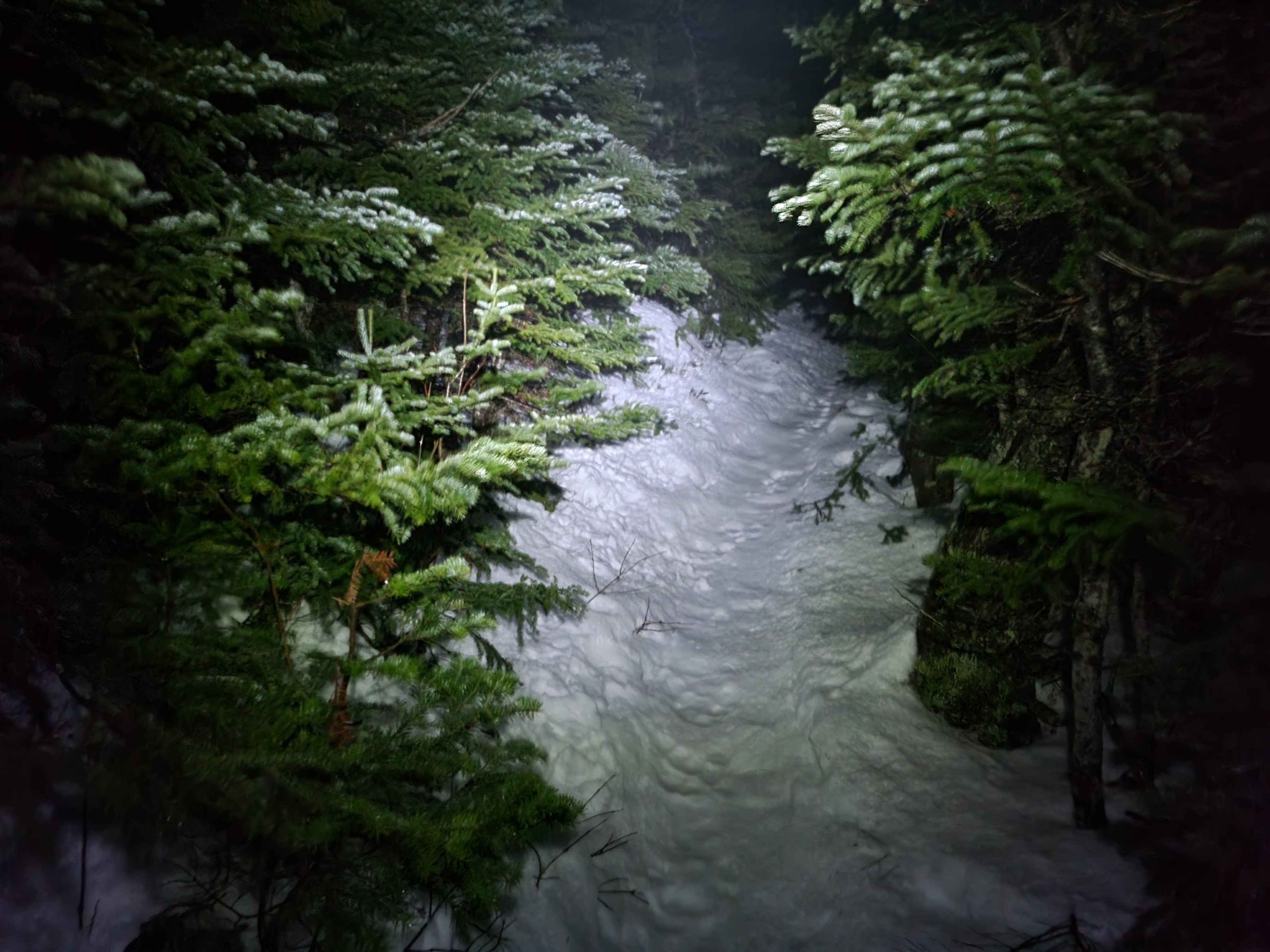
By the time I reached the alpine zone near the top of Bondcliff, still almost 2 miles from Guyot Shelter, it was a significant struggle to keep moving. I’d been trudging doggedly up the mountain for 2.5 hours at this point, already much longer than I had planned on, and my trudge was on the edge of becoming a shamble. When the trail began disappearing on me, I was ready to be done. The darkness and lack of vegetation above tree line would normally have made route-finding difficult enough, but the foggy, rainy conditions meant that my headlamp glared horribly back into my face. I could barely see more than a few feet in front of me. The snow had grown deeper as I climbed, to point that normally if I stepped off the beaten path, I’d sink to my shins, but the windswept alpine zone was more rock than snow, so that too was of limited usefulness for route-finding.
The cold mountain winds blasted me as I slowly worked my way across the mountaintop. It was fortunate that the trail followed the ridge and was well marked with cairns and rock paths, because I’m sure I missed 90% of them. I would turn my headlamp off briefly to try to spot the characteristic bump of a cairn in the vague silhouettes of the mountain’s edge and was regularly checking my phone to be certain I was still near the trail. At one point I heard a thump of falling gear behind me, and turned to see the wind had blown my sleeping pad off of my pack and away from me. I was able to pin it to the ground with my trekking pole, but a moment slower and it would have blown off into the darkness and been gone forever. While this was slightly terrifying, the brief spike of adrenaline was helpful to break up the monotony and keep me moving. Add to that the additional mental effort of route-finding, and I was actually able to momentarily forget about the pain in my legs. It was a much needed reprieve while it lasted, and gave me a sort of second wind to keep moving.
Once I got out of the alpine zone and back into trees, the trail was easy enough to follow. Putting one foot in front of the other was a different story. I was utterly exhausted, and since the trail after Mt. Bond wasn’t packed out, I was sinking to my shins in snow with every step. I’m pretty sure I was only able to keep moving because I was going downhill, so the ten inches I sunk with every step was still technically in the direction I needed to be moving. I considered putting on my snow shoes, but that would have required stopping, sitting, and fiddling with them for a bit. I was too cold and wet for that, and close enough now to camp that I just wanted to push on to the end.
Relief flooded me when I saw the sign declaring that I was now entering a Forest Protection Area. These are a quarter mile radius zones around campsites in the White Mountains where additional restrictions apply to minimize damage in the high use areas. To me, it meant I was less than half a mile from rest. I continued shambling down the trail, very ready to be done.
The designated spur trail descended steeply from the right side of the trail for almost a quarter of a mile, and I was very glad to see the caretaker’s platform that marked my arrival at the campsite. As if part of some cruel joke, the shelter was at the far side of the area, forcing me to walk as far as possible past all the tent platforms before finally reaching it. I hobbled up the stairs and inside and promptly dropped my backpack to the floor.
Once I had that weight off my back, the rest of the evening was actually fairly pleasant. I changed into my dry clothes, put on all my insulation, then crawled inside my sleeping bags (I had a second sleeping bag with me to act as a quilt and provide more warmth) and started cooking dinner. I wasn’t able to eat all of it immediately, but my hiker hunger seemed to be kicking in, and throughout the evening and the few times I woke up in the night, I finished what remained of it, as well as half a bag full of trail mix.
My phone still had about 80% battery left, so I felt comfortable listening to my audiobook for about an hour as I fell asleep. My blood sugar only went low once in the night, and a few sugar tablets were more than sufficient to treat it. I’d probably set my basal slightly too high for the night, as active as I had been during the day. But at least I was resting, and tomorrow would be nice and short, giving me plenty of time to recover.
Hike Details
- Distance: 11.65 miles
- Date: 12/11/21
- Route: https://www.alltrails.com/explore/map/map-january-11-2022-3-24-pm-2e09926

2 thoughts on “Mountains of Pain, Part 1”